

A Fire Weather Watch—often a precursor to the more severe Red Flag Warning—was issued Friday afternoon by the Portland office of the National Weather Service for Friday, September 9 at 11 a.m. through Saturday, September 10 at 5 p.m.
“A strong area of low pressure will bring an increased chance for strong easterly winds with critically dry conditions on Friday night into Saturday,” the NWS watch text read.
The area the watch is in effect stretches across the Willamette Valley and includes the Coast Range and the Cascade Range.
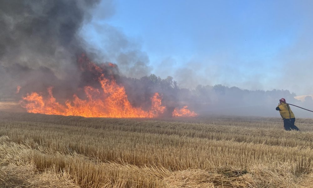
With northeast winds of 8 to 17 mph with gusts as high as 25 mph at higher elevations, the forecast is a grim reminder of the windstorm that spread wildfire into Oregon’s worst fire season during Labor Day weekend in 2020.
Relative humidity is expected to drop to as low as 14 percent, with temperatures locally forecast into the upper 90s.
A Fire Weather Watchmeans that “conditions may be favorable for rapid fire spread which may threaten life and property,” the NWS said. The federal agency urged extra caution with potential ignition sources and cautioned against outdoor burning.
A burn ban remains in effect in Washington County.
In an email signed by three local district foresters with the Oregon Department of Forestry, the officials updated local landowners and industrial forest operators on the upcoming weather conditions.
“These conditions are the worst so far for 2022. Dangerous conditions will start Friday morning, peak Friday night, and remain on Saturday,” the email read.
“During this time fires will start easily and spread quickly,” the officials said. “Activities such as target shooting, chainsaws, campfires, and debris burning have a history of starting fires here in Northwest Oregon and will be risky this weekend. Landowners and response agencies are preparing for the conditions and are urging the public to be careful.”
Fire danger in most of the Tillamook State Forest and the surrounding ODF-protected land remains at high, but that will change early Friday morning, with ODF officials placing all weather zones stretching from the coast to the edge of the region at “Extreme” fire danger.
Under Extreme fire danger, significant restrictions on recreational and public use of state protected lands kick in. More information on restrictions can be found at www.oregon.gov/odf/fire/Pages/restrictions.aspx.
“While in Extreme all campfires are prohibited, trails are closed to motorized use, and most spark emitting activities are also prohibited, such as welding in the forest environment, non-industrial use of chainsaws, and mowing of cured grasses,” the ODF officials noted.
Fire officials also urged residents to be prepared for power outages, which could come from downed limbs, fire activity, and intentional shutoffs from electric utility companies seeking to reduce the risk of fires starting during high wind events.
“This is a similar weather set up as what occurred for the Labor Day fires in 2020, but thankfully not as strong,” Forest Grove Fire & Rescue said in a social media statement.
“We’re monitoring conditions in limited, high-risk areas over the next few days, because the danger for fire is high,” Portland General Electric said in a statement.
Forest Grove Fire & Rescue listed the following ways to prepare for wildfires and other impacts extreme fire danger can cause:
The best thing to do is prevent fires from starting in the first place.
-ALL Debris burning is still banned in Washington County.
-Properly discard cigarettes, never throw them out of a vehicle.
-Avoid outdoor yard work with power equipment.
-Limit recreational fires.
-We advise to just stay out of the forest this weekend, don’t go target shooting or hunting.
-Don’t park on dry grass.
-Secure trailer chains so they don’t drag and spark.
-Check local fire restrictions if traveling out of our area.
If a fire occurs in your area.
-Know the different evacuation levels.
-Only call 911 if there is an immediately threat to life or property. Don’t call 911 to find information.
-Pay attention to local agencies for updated factual information.
-Keep mobile devices charged up to stay informed. Sign up for alerts here: https://www.publicalerts.org/signup
Power Outages.
-If you see a downed power line, don’t touch it.
-If vegetation gets knocked into a power line, it could knock out power for an extended time period.
-Power companies could cut power to dangerous areas to prevent fires from starting.
-Be prepared for prolonged power outages, think of ways to keep yourself cool during the heat as well as ways to eat.
A Fire Weather Watch means that critical fire weather conditions are forecast to occur. Listen for later forecasts and possible Red Flag Warnings.

Chas Hundley is the editor of the Gales Creek Journal and sister news publications the Banks Post and the Salmonberry Magazine. He grew up in Gales Creek and has a cat.