

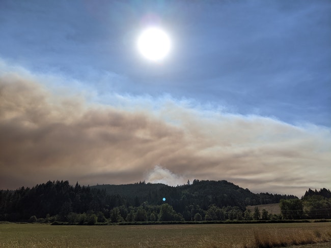
 Smoke from the Powerline Fire drifts into more smoke from other Oregon wildfires. Photo: Chas Hundley
The active fire burning south of Hagg Lake is largely uncontained, Forest Grove Fire and Rescue public information officer Matt Johnston said, speaking to members of the press at the parking lot of the Lake Stop Grocery on Old Highway 47 Road.
Behind him, a blanket of smoke obscured the horizon – a product not just of the Powerline Fire burning south of the lake, but of fires raging elsewhere in Oregon.
The fire has been referred to as the Stimson Mainline Fire, but Johnston said that the ‘official’ name has been settled on as the Powerline Fire.
It was hard to pinpoint the exact size of the fire. Johnston said that his best guess would put it at 25 to 50 acres. “That’s a very big guess,” he said. Due to its remote location in rough terrain with limited vehicle access on old logging and powerline roads between Cherry Grove and Hagg Lake, sizing it up proved difficult.
 We rely on subscribers to keep the lights on at the Gales Creek Journal. Support us with a digital subscription: Click here to start
According to Johnston, crews were first notified that a wildfire was burning on Tuesday morning after 6 a.m. near Dundee Road. Stimson Lumber personnel also called in a fire around the same time. But pinpointing the exact location was initially a struggle.
According to Johnston, the fire was sparked by a downed West Oregon Electric Co-op power line; the utility had earlier said that they would be cutting power from 9 p.m. on Monday to 3 a.m. on Tuesday in the area.
WOEC said that they will once again turn power off in the Hagg Lake area Tuesday evening, as well as the Pike, Patton Valley, Haskins Creek, Mt Richmond and surrounding areas, and on Keasy Road from just past Creek View Lane to to the end of Keasy Road.
Johnston said that the fire was active, and had forced firefighters to back away from certain areas as high winds continued to push it from where it had originally been burning in younger trees that had been planted after a logging operation in the area. From there, the flames spread to slash piles left from prior logging operations, and then into standing timber.
early Tuesday evening, the fire was still active and still growing, with limited resources available to tackle the fire due to the widespread wildfires in jurisdictions all over the state.
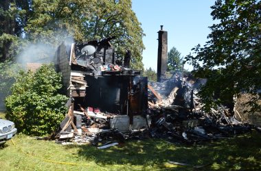
As of 4 p.m., the fire had not damaged any structures.
At this point, Johnston believes the fire to be at around a 10% containment, a term he cautioned can mean very little in terms of controlling the spread of a fire. A fire can have some percentage of containment and continue to grow in size.
A number of crews were on scene, around 60 or 70 total personnel, with five vehicles expected to arrive around 5 p.m. from Clatsop County to aid and give some of those who’d been on scene since the morning a break. A Banks resident noted fire vehicles, at least one from Nehalem Bay Fire and Rescue, driving through Banks just before 4:45 p.m. Tuesday.
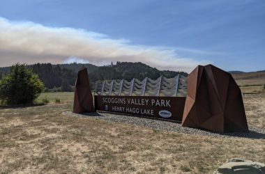
Those who have aided in fighting the fire include Gaston Fire District, whose jurisdiction the fire is burning in, Forest Grove Fire & Rescue, Banks Fire District 13, Cornelius Fire Department, Vernonia Rural Fire Protection District, Hillsboro Fire & Rescue, Tualatin Valley Fire & Rescue, Oregon Department of Forestry crews, a ten person prison crew from South Fork Forest Camp, Carlton Fire and Ambulance, Dundee Fire Department, Metro West Ambulance, Stimson Lumber and other private contract crews, as well as rangers from the Washington County Parks department, who were stationed at the Scoggins Valley Park entrance to direct traffic.
Also on scene were about 30 deputies from the Washington County Sheriff’s Office, who were going door to door to notify residents of the various evacuation orders given throughout the day, said Washington County Sheriff’s Office spokesperson Danny DePietro. The majority of residents heeded the evacuation notice, but a handful of residents opted to stay despite the risk, DePietro said.
Presently, all of Dundee Road, Patton Valley Road, Cascara Drive, Lee Road, and the community of Cherry Grove are under a Level 3 evacuation order, which means to leave immediately due to imminent or current threat; under a Level 2 evacuation order is South Road between Mt. Richmond Road (an earlier scheduled closure slated to begin tomorrow on Mt. Richmond Road has been postponed, according to Washington County LUT) and Cherry Grove.
For those impacted by a wildfire, the nearest Red Cross evacuation point is at Neil Armstrong Middle School in Forest Grove, located at 1777 Mountain View Ln, Forest Grove.
For additional evacuation orders as conditions change, check the Washington County Sheriff’s Office Twitter page.
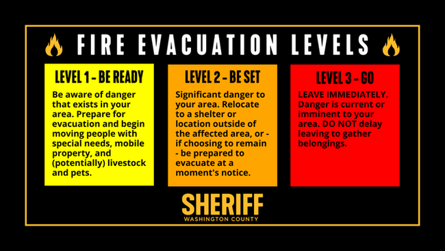 A graphic from the Washington County Sheriff’s Office explaining different levels of evacuations
This article has been updated to include additional information from WOEC regarding a planned power shutoff in the Hagg Lake and other areas, to add to the list of known agencies that responded to the fire, and to add evacuation point information.

Chas Hundley is the editor of the Gales Creek Journal and sister news publications the Banks Post and the Salmonberry Magazine. He grew up in Gales Creek and has a cat.